 The man who coined
that phrase, the Australian Historian Geoffrey Blainey,
wrote an article a few weeks ago called ‘Tyranny of distance dies hard’
(Financial Review, so it’s not free online). In it he talks, as you can
imagine, about the distance that still separates us from continental Asia. ‘Every city in
Europe is closer to Continental Asia
than are Melbourne, Sydney
and Perth. Australia –
or the region where most of us live – is not close to china’. And, as he argues, since the world is
shrinking, it affects everyone and what matters is relative advantage. Now,
Geoffrey Blainey is to the best of my knowledge not overshoot aware and he is
using a simplification in the quote above, for fairly simple reasons based on
the myth of progress and simplicities sake. Since sea travel is traditionally
better than an equivalent land route, we are qualitatively closer to Asia than Europe is, however since in the progress view of the world
air-travel is becoming more common and important, distance as the crow flys is
more important. While a post overshoot world could still have airships
to keep this trend, in an overshooting world the infrastructure necessary won’t
be built on anything but a regional scale (if at all). As for Overshoot, well
its affects from distance increase can only be seen with time, however, we can
look at some of the relevant factors; the fate of the two major canals (Suez and Panama), the clipper route, sea level rise and
climate change, the maintenance of docks, and piracy. From this a framework of
how the tyranny of distance could play. From there, its affects on life can be
guessed, whether it’s how a journey man system could pop up, skill exchanges,
pilgrimages to the travel some farmers do after harvest, and so on.
The man who coined
that phrase, the Australian Historian Geoffrey Blainey,
wrote an article a few weeks ago called ‘Tyranny of distance dies hard’
(Financial Review, so it’s not free online). In it he talks, as you can
imagine, about the distance that still separates us from continental Asia. ‘Every city in
Europe is closer to Continental Asia
than are Melbourne, Sydney
and Perth. Australia –
or the region where most of us live – is not close to china’. And, as he argues, since the world is
shrinking, it affects everyone and what matters is relative advantage. Now,
Geoffrey Blainey is to the best of my knowledge not overshoot aware and he is
using a simplification in the quote above, for fairly simple reasons based on
the myth of progress and simplicities sake. Since sea travel is traditionally
better than an equivalent land route, we are qualitatively closer to Asia than Europe is, however since in the progress view of the world
air-travel is becoming more common and important, distance as the crow flys is
more important. While a post overshoot world could still have airships
to keep this trend, in an overshooting world the infrastructure necessary won’t
be built on anything but a regional scale (if at all). As for Overshoot, well
its affects from distance increase can only be seen with time, however, we can
look at some of the relevant factors; the fate of the two major canals (Suez and Panama), the clipper route, sea level rise and
climate change, the maintenance of docks, and piracy. From this a framework of
how the tyranny of distance could play. From there, its affects on life can be
guessed, whether it’s how a journey man system could pop up, skill exchanges,
pilgrimages to the travel some farmers do after harvest, and so on.
The Canals: The two major canals, the Panama and the Suez, as you can infer from the map above,
drastically changed shipping routes. While they are a product of the early
industrial age, Napoleon was involved in the initial surveying of the Suez canal and the Panama was finished in the same year that WW1
started, they will not necessarily disappear with the Industrial age. Most of
the work has already been done and smaller canals have been built and
maintained well before the Industrial age came along, and both sites offer some
ability to pursue large projects. The type of labour force that built the
pyramids, farmers when the Nile was flooding (provided it starts again), could
easily be used to maintain the canal, especially if the level of ingenuity and
mechanical aptitude used in the pyramids remains. And the Panama has access to biofuels; Brazilian ethanol
has the highest EROEI (10) I have heard of for ethanol, with which to help the
labour. What could destroy; or more likely shut them down for periods of time,
is a mixture of suppressed maritime trade, increased piracy and rising passage
fees; The Caribbean and the Mediterranean have both been homes of pirates
throughout history. A sharp and sudden economic/political dislocation could
also shut them down, until the freeing up of resources that is part of
catabolic collapse allows them to be reopened. Either way, the clipper route is
likely to start up again and while it is unlikely to gain its former place, it
will once again be an important part of the global economy and maritime travel.
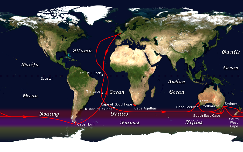
The Clipper
Route: The natural sailing route that lies along the far
southern hemisphere, courtesy of the roaring forties and furious fifties, the
image above is of the route. It was the fastest, most rewarding and dangerous
route of its time, chances are it will be again. It goes along the south coast
of Australia, which is a blessing because since that’s near where most of
Australia’s population lives and it is also the most dangerous route (by
nature), which makes any hostile movements using it unwise, or easily defended
against, look up the Mongol invasions of Japan (key word: Kamikaze), at least
from outside Australia. This route actually makes Perth close enough, qualitatively,
that WA could conceivably remain part of some form of federation (I’d say a
about even) .The main problem is that climate change could disrupt, change or
make it even more dangerous, which would most likely be to Australia’s
detriment.
Pirate Zones: Directly north of Australia is likely to be a pirate zone, these
pirates would most likely use small boats that range from canoes to small
fishing boats. The pirates will be especially thick in the closed (if that’s
the right term) waters of the various straits and where the local governments
have broken down or are resorting to piracy. This could often cut of
continental Asia and some of the northern islands, however
its more likely to restrict and suppress travel rather than stop it. The Mediterranean and Persian Gulf will also suffer from a similar pirate infestation,
think Somalia or the Barbary pirates (the USA went to war with them), especially when
the Suez canal is operational. While the pirates here
could (and probably will) use bigger ships, canoes and small sail (possibly
some motor as well) boats will work fine here. The Barbary pirates used rowboats to capture merchants
and one US warship (idiot captain). This will only
affect Australia while the Suez is operational, and the clipper route will
alleviate it somewhat. The Caribbean
is likely to regain its pirates, and these will be closer to the ones in
popular culture, hopefully they’ll also be democratic (with constitutions) like
their predecessors (yes pirates back then were democratic, to a degree). These
pirates will be a problem for anyone travelling to the East coast of N.America,
whether or not the Panama is closed, and unfortunately the East coast is the
Wealthier and more hospitable of the N.American coasts. Now, if you think this
sounds easy to deal with, remember, I haven’t even mentioned the privateers
(state backed pirates) that could easily arise.
Sea level rise and Climate Weirding: Heres a flood map, it’s useful to examine the
changes to Australia based on sea level rise. Since we’re a
mostly coastal country, even if you don’t live near the coast, these changes
will impact you severely in everyday (and not everyday) life. Now as a
reference, the last figure I’ve heard on sea level rise is that it’s expected
to be between 6 and 13 metres, however that basis was on a continued rise in
fossil fuel use. Extrapolate, as you will and research on your own. Now, from
my personal experience, most of Australia’s coastline is quite rugged and won’t
be largely impacts by sea level rise, however some parts of it will be,
especially the port cities were people live. As shown on the map, the impact
isn’t going to be the apocalyptic with the current coastline utterly abandoned
scenario that most (or at least the ones I hear) climate change activist say it
will be. However, we have the second change brought about by global warming,
climate Weirding. Since this means that current natural disasters, specifically
(in this case) hurricanes, typhoons, tornadoes and coastal floods, will become
more common and appear in new areas, they will amplify and feed off the impacts
of sea level rise, based on the current locations of such disasters (Queensland
and NT), this is likely to spread south to NSW and will make Queensland and NT a
bit more inhospitable.
Coastal and Supporting Infrastructure: Since container ships are likely to
disappear and sails will gradually replace diesel, both the supporting (mostly
manufacturing) and direct (docks and such) shipping infrastructure will need to
be rebuilt. This section is going to degrade no matter what as one of the
consequences of overshoot. Since all the supporting infrastructure, rails,
roads, manufacturing, forest (if wooden ships), sheep farms (sails) and so on,
is also going to need to be created, replaced or upgraded, and is also going to
decline, then the uptake of sailing ships will follow the catabolic collapse
pattern. That is, after periods of decline and collapse, things will cycle up
before they decline further.
No comments:
Post a Comment